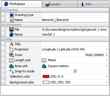
A workspace includes the following characteristics:


CM-MAN~3_img481


Characteristic

Description

Workspace

General workspace characteristics


CM-MAN~3_img482

File

*.mws file and file path of current map

CM-MAN~3_img483

Name

Name of workspace

Drawing

Interface to ConnectMaster drawing administration


CM-MAN~3_img484

Drawing type

ConnectMaster drawing type of ConnectMaster drawing.

CM-MAN~3_img485

Name

Name of ConnectMaster drawing in the Drawing Administration.

Map

Map characteristics


CM-MAN~3_img257

Title

Map title; is displayed on the map.


CM-MAN~3_img487

Projection

The projection and coordinate system on which the map is based; for details, see below.


CM-MAN~3_img488

Zoom


CM-MAN~3_img489

Length unit

The unit for length measurements that is used in the map; for details, see below.


CM-MAN~3_img490

Surface unit

The unit for surfaces that is used in the map.


CM-MAN~3_img491

Catch mode

If the catch mode is enabled, the cursor in the map is automatically set to a selected element (element is “caught” by the cursor).


Selection colour

Colour setting for selected elements.


Background colour

Colour setting for map background.


In detail:

Projection

The projection model and coordinate system of the current map is set under “Projection”. The projection model describes how objects of a spherical surface area are represented on a two-dimensional surface area (of the map).  The coordinate system describes how elements are physically arranged on the map.  

Many different coordinate systems and projection models can be selected under “Projection”

Length unit

A list of length units are available, e.g.

All metric length units (kilometres, metres, centimetres, millimetres)

Miles (standard and nautical)

Chains

Foot

Grade

Rods

US survey foot

Yards

Inch